
Every day, our regions face a range of risks and threats. In this context, every citizen must have access to useful information so that they are prepared to deal with any crisis situation.
Faire Face 72 is a website that allows each municipality or inter-municipal authority to easily create its own website and risk map to prepare the population for exceptional events.
Three sections are available to citizens to introduce them to individual and collective resilience: get informed, adapt, prepare.

By learning about the risks to which their municipality is exposed, every citizen can improve their resilience in the event of a disaster.

Before any event, every citizen can reduce their vulnerability to hazards by adopting the right reflexes and protecting their family and home.

To cope for 72 hours, it is important that every citizen organises themselves and puts together their own emergency kit based on their household and the risks.
72 hours is the amount of time during which essential services are likely to be affected following a major event. Every citizen must therefore be as self-sufficient as possible so that emergency services can focus on the most important thing: saving lives.
Provide your citizens with an interactive online map showing the major risks in your municipality and the associated protective measures.
A simple, effective tool dedicated to preventive information
Easy for your municipal teams to administer, this tool allows you to disseminate clear and up-to-date information before, during and after a disaster. By promoting a culture of risk awareness upstream, it helps citizens to be better prepared. During a crisis, it provides accurate geolocation data for a rapid and coordinated response. After the event, it facilitates impact monitoring and post-crisis communication.
Thanks to its online interface, each local authority can create its own website in half a day. All it has to do is choose the content it wants to display on its website (information documents, Twitter feed, Mayor's message, videos, kits).
This service is available to local authorities that are members of the HCFRN. Contact us for more information.
Each local authority can register online. It then has access to digital resources (a video tutorial and a practical guide) to create and publish its website in just a few clicks. A telephone support service is also available.
Contact us for a demonstration.
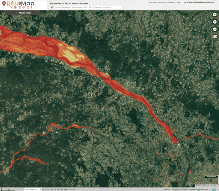

The map, which is managed directly by the local authority, enables citizens to be informed before, during and after a disaster thanks to geolocated data, thereby enhancing their safety and resilience.
Twitter feeds Keep your population informed by displaying 1 to 3 Twitter feeds: profile, hashtag or list. You can display feeds from the authorities, local media or civil security associations.
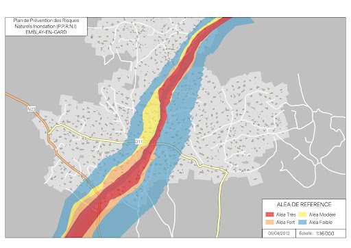
Make your information documents (DICRIM, information brochures, etc.) available in PDF format by uploading them directly via your configuration interface.
Strengthen your residents' risk culture with video testimonials filmed after the floods in the Alpes-Maritimes and Var regions in October 2015.
Use short, fun cartoons to teach your residents the right reflexes and behaviours to adopt in the event of an exceptional event.
Tick the risks to which your area is exposed and display the corresponding infographics. Each infographic illustrates the appropriate behaviour before, during and after a crisis.
19 infographics are available on natural, technological and societal risks. They include the instructions published on the website www.risques.gouv.fr

Encourage your residents to put together their own illustrated emergency kit. Depending on the characteristics of your local area, activate different Faire Face 72 kits: for mountainous areas, tropical areas, floods or health risks.
Each citizen can put together their own Faire Face 72 kit in just a few clicks, so that everyone has what they need to deal with an emergency (infants, vulnerable people, pets, etc.).
Discover a new version of the PFMS, practical, fun and concise, so that everyone has the information they need to take action and keep themselves and those around them safe.
Contact us to create a FF72 website for your local authority.